


 KINGSTON, JAMAICA:--- Hurricane Melissa continued to strengthen on Sunday evening as it churned slowly toward Jamaica, threatening to unleash catastrophic flooding, violent winds, and dangerous storm surge within the next 24 hours.
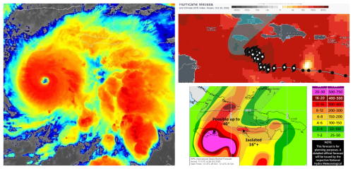
According to the National Hurricane Center (NHC), Melissa remains a powerful Category 4 hurricane with maximum sustained winds near 145 mph (230 km/h). As of Sunday afternoon, the storm’s center was located about 120 miles (190 km) south-southeast of Kingston, moving west-northwest at a sluggish 3 to 5 mph (6–8 km/h).
Forecasters expect the hurricane to make landfall late Monday or early Tuesday, likely along Jamaica’s southern coastline, bringing the potential for the most destructive impact on the island in decades.
“Melissa has the potential to be the strongest storm ever to make landfall in Jamaica,” warned NHC Director Michael Brennan. “Residents should prepare for catastrophic winds, flash flooding, and life-threatening storm surge.”
Jamaica Under Hurricane Warning — Residents Urged to Take Shelter
The Meteorological Service of Jamaica and the NHC have issued a Hurricane Warning for the entire island. Authorities are urging residents in flood-prone and coastal communities to evacuate or seek safe shelter before conditions deteriorate on Monday morning.
Prime Minister Andrew Holness addressed the nation Sunday evening, announcing that emergency shelters are open and government agencies are fully activated.
“We must treat this storm with the utmost seriousness,” Holness said. “Do not wait until tomorrow to act. Secure your homes, safeguard your families, and move to safety tonight.”
The Office of Disaster Preparedness and Emergency Management (ODPEM) confirmed that over 900 shelters are ready and supplies are being distributed across all parishes. The Jamaica Defence Force (JDF) is on standby for rescue operations once conditions allow.
Forecast Impacts: Wind, Rain, and Surge
Meteorologists predict that hurricane-force winds — exceeding 130 mph in some areas — will begin lashing Jamaica by Monday afternoon.
- Rainfall: 15 to 30 inches (380–760 mm) expected island-wide, with isolated totals up to 40 inches (1,000 mm) possible in the Blue Mountains and interior parishes, posing extreme flood and landslide risk.
- Storm Surge: Up to 13 feet (4 m) of surge along Jamaica’s south coast, especially near Old Harbour Bay, Clarendon, and Westmoreland.
- Winds: Sustained hurricane-force winds over central and southern parishes by Monday night.
“This is shaping up to be a prolonged, dangerous event,” said Evan Thompson, Director of the Meteorological Service. “Melissa is moving slowly, which means more rainfall and flooding over time.”
Preparations Underway Nationwide
Airports, ports, and schools have been closed across Jamaica as residents rush to complete last-minute preparations. Gas stations saw long lines Sunday, and hardware stores quickly sold out of generators, batteries, and plywood.
Local authorities have urged motorists to remain off the roads starting Sunday night, as outer rainbands and squalls are already being reported along the south and east coasts.
In Kingston, businesses have boarded up storefronts while emergency crews began clearing drains and reinforcing flood defenses.
A Historic and Dangerous Storm
Hurricane Melissa’s rapid intensification over the Caribbean Sea has alarmed forecasters. Warm waters, low wind shear, and slow movement have allowed the system to strengthen steadily since Friday.
If Melissa maintains its strength at landfall, it would likely surpass Hurricane Gilbert (1988) and Hurricane Dean (2007) as the strongest storms to directly hit Jamaica in modern history.
After Jamaica, Melissa is projected to move toward southeastern Cuba and possibly the Bahamas by midweek, still at major-hurricane strength.