


 A Small Craft Advisory Remains in Effect for St. Maarten until TUESDAY
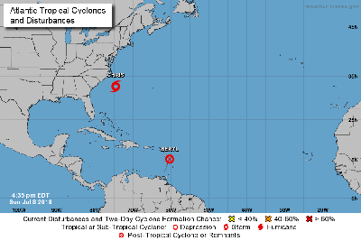
PHILIPSBURG:--- At 5PM, the remnants of Beryl was located near latitude 15.2 North, longitude 60.3 West or about 270 miles southeast of St. Maarten. The remnants are moving toward the west-northwest at 26 mph (42 km/h). This west north-westward motion is expected to continue into Monday.
On the forecast track, the remnants of Beryl will approach the Lesser Antilles this evening and cross the island chain overnight. Maximum sustained winds are near 45 mph (75 km/h) with higher gusts. Slight weakening is forecast during the next 24 hours. Conditions could become conducive for regeneration when the remnants move across the Bahamas. Tropical-storm-force winds extend outward up to 45 miles (75 km), mainly to the North and Northeast from the center.
The estimated minimum central pressure is 1007 mb (29.74 inches).
EXPECTED HAZARDS AFFECTING ST. MAARTEN WIND:
Gusty winds up to 26 knots/30 mph can be expected Sunday night through Monday with occasional higher gusts.
SEAS: Seas are deteriorating, swells of up to 10 feet are expected. Small craft operators and sea bathers should be vigilant. A small craft advisory for St. Maarten is in effect.
RAINFALL: Accumulations of 2 to 3 inches of rainfall is expected; some flooding is possible. ALL RESIDENTS/VISITORS SHOULD REMAIN VIGILANT AND KEEP UPDATED.
THE METEOROLOGICAL DEPARTMENT WILL CONTINUE TO MONITOR TROPICAL STORM BERYL AND ISSUE SPECIAL WEATHER BULLETINS.
The next update will be issued today at 8PM (24:00 UTC).