


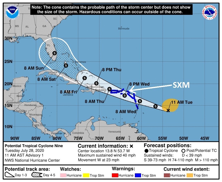
 PHILIPSBURG:--- At 1100 AM (1500 UTC), the potential tropical cyclone was centered near latitude 13.8
North, longitude 53.7 West or about 690 miles east-southeast of St. Maarten. The system is moving toward the west near 23 mph (37 km/h). This general motion should continue for the next several days. On this forecast track, the system is forecast to move through the our
the region on Wednesday.
Maximum sustained winds are near 40 mph (65 km/h) with higher gusts. Some strengthening is expected during the next 48 hours and the system is forecast to become a tropical storm tonight or Wednesday.
Tropical-storm-force winds extend outward up to 230 miles (370 km) primarily to the northeast of the center. The estimated minimum central pressure is 1007 mb (29.74 inches).
HAZARDS AFFECTING LAND:
WIND: Windy conditions could begin late tonight through Wednesday on St. Maarten. RAINFALL: The potential tropical cyclone will produce total rain accumulation of 2 to 6 inches. This rainfall could produce flash flooding and rockfalls.
SEAS: Sea conditions will continue to deteriorate and peak by Wednesday afternoon with swells up to 15 feet. A small craft advisory and flash flood advisory will go into effect later today.
Tropical Storm Warning Issued for Sint Maarten. Residents advised to prepare for tropical storm conditions
As of 11.00 am on Tuesday morning, Sint Maarten is under a Tropical Storm Warning.
A tropical storm warning means that tropical storm conditions are expected in the warning area within 36 hours.
The weather system has been classified as a potential tropical cyclone. The forecast track has the system moving through our region on Wednesday.
The system is expected to become a tropical storm tonight or Wednesday. Tropical-storm-force winds extend outward up to 230 miles primarily to the northeast of the center.
Maximum sustained winds are near 40 miles per hour with higher gusts. Some strengthening is expected during the next 48 hours.
The Fire Department/Office of Disaster Management (ODM) Fire Chief Clive Richardson, is calling on the community to continue to closely monitor the progress of the weather system and to prepare for the possibility of tropical storm conditions.
According to the Meteorological Department of Sint Maarten (MDS) in a special bulletin on Tuesday at midday, windy conditions could begin late tonight through Wednesday.
RAINFALL: The potential tropical cyclone will produce total rain accumulation of 2 to 6 inches. This rainfall could produce flash flooding and rock falls.
Residents in areas prone to flooding or near the coast should make the necessary preparations to protect life and property, the MDS said on Tuesday.
Motorists are advised to stay off the road during heavy rain events if you do not have to be out; hillside residents are advised to remain indoors during heavy rainfall due to possible rock and landslides.
Motorists are advised to stay away from flood-prone areas during heavy rainfall such as:
LB Scot Road - from Emilio Wilson Park until Cake House.
Zagersgut - from Petro Plus Gas Station until Seventh Day Church.
Wegelegen Road Cayhill - from Wegelegen road Roundabout until One Tete Loke Roundabout.
Beacon Hill Road - from Sunset Bar & Grill until the beginning of White Sands Road.
Rhine Road - from the intersection of University Drive until the intersection of Rio Grande.
SEAS: Sea conditions will continue to deteriorate and peak by Wednesday afternoon with swells up to 15 feet. A small craft advisory and flash flood advisory will go into effect later
today.
The remaining storm names for the 2020 Atlantic hurricane season are Isaias, Josephine, Kyle, Laura, Marco, Nana, Omar, Paulette, René, Sally, Teddy, Vicky, and Wilfred.
For those who would like to learn more about hurricane hazards and how to prepare for a storm/hurricane strike, you can visit the Government website: www.sintmaartengov.org/hurricane where you will be able to download your “Hurricane Season Readiness Guide’ and “Hurricane Tracking Chart.”
In addition, you can also download the ‘Disasterprep Sint Maarten’ app for Android and Apple phones by going to the Google and Apple stores.
ODM reminds residents and business owners to have plans in place for quick action when the need arises – storm ready!
Listen to the Government Radio station – 107.9FM - for official information and news before, during, and after a hurricane.
For official weather-related information, check out the website of the Meteorological Department of St. Maarten (MDS): www.meteosxm.com
Remember, it only takes one hurricane to make it a bad season. Are You Ready? Be prepared for this hurricane season!