


 Hurricane Jerry is weaker and has decreased to a Category 1 hurricane. It is moving toward the west-northwest near 17 mph
(28 km/h).
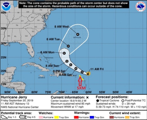
On the forecast track, the center of Jerry is expected to pass approximately 120 miles to the north of St. Maarten late tonight. Effects of Jerry on St. Maarten is expected to be mainly in rainfall and sea swells from later this afternoon and tonight.
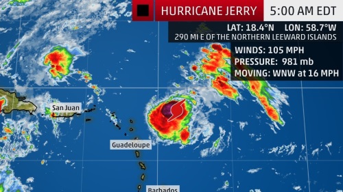
Maximum sustained winds have further decreased to near 85 mph (140 km/h) with higher gusts.
Additional weakening is forecast during the next day or so, with some re-strengthening possible early next week.
Hurricane-force winds extend outward up to 15 miles (30 km) from the center and tropical-storm-force winds extend outward up to 80 miles (130 km).
The estimated minimum central pressure recorded is 990 mb (29.24 inches).
Residents and the general public are advised to continue being alert and monitor the progress of Jerry.
The Meteorological Department of St. Maarten will continue to monitor and issue special weather bulletins.
POTENTIAL IMPACTS FOR ST. MAARTEN:
Rainfall: Jerry is expected to produce total rainfall accumulations of 1 to 4 inches. Increasing cloudiness with showers and thunderstorms are expected as the day progress. Most of the significant showers are expected from later this evening into Saturday. Flooding and/or rock slides can be expected in flood-prone areas and along hillsides. Residents and users of these areas are advised to be vigilant.
Winds: Gusty winds could accompany showers later today through Saturday.
Seas: Swells up to 12 feet are possible during the passage of Hurricane Jerry, mainly along the northern and eastern shores. These swells are likely to cause life-threatening surf and rip current conditions. Beach erosion is possible in vulnerable areas. Sea-bathers are advised to stay away from the sea during the passage of Jerry.
At a Glance
Jerry is likely to move north of the northern Leeward Islands, where tropical storm watches are in effect.
Some of those islands could get brushed by outer rainbands producing locally heavy rain and gusty winds.
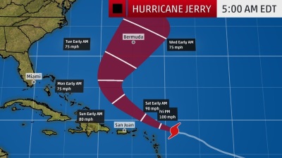
Jerry could move near Bermuda next week.
Hurricane Jerry will track north of the Leeward Islands beginning Friday, though it could still brush some of those islands with locally heavy rain and gusty winds. Jerry could also threaten Bermuda next week which is cleaning up after being battered by Hurricane Humberto.
Jerry is centered more than 200 miles east of the northern Leeward Islands and is tracking west-northwestward.
Current Storm Status
(The highest cloud tops, corresponding to the most vigorous convection, are shown in the brightest red colors. Clustering, deep convection around the center is a sign of a healthy tropical cyclone.)
The center of Jerry is forecast to track north of the northern Leeward Islands on Friday, then well north of Puerto Rico on Saturday. It's expected to be well east-northeast of the southeastern Bahamas on Sunday.
Tropical storm watches have been issued for the islands of St. Maarten/St. Martin, St. Barthelemy, Saba and St. Eustatius in the northern Leeward Islands. This means tropical-storm-force winds (39-plus mph) are possible within the watch area – in this case, within 24 to 36 hours.
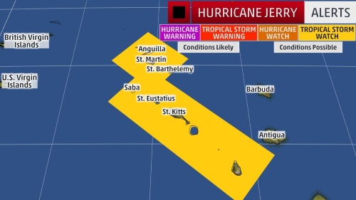
Watches and Warnings
(A watch is issued when tropical storm or hurricane conditions are possible within 48 hours. A warning is issued when those conditions are expected within 36 hours.)
Even though Jerry will track north of those islands, they could experience tropical storm conditions on Friday as outer rainbands rotate around the system.
Jerry is expected to produce total rainfall accumulations of 1 to 3 inches – with isolated spots receiving 4 to 6 inches – from Barbuda northwestward across St. Maarten/St. Martin, Anguilla and Anegada. This rainfall may produce life-threatening flash flooding.
The Virgin Islands and Puerto Rico can expect 1 to 2 inches of rainfall, with maximum totals up to 3 inches.
Jerry will most likely angle toward the northwest by late in the weekend, then toward the north and northeast early next week, according to the National Hurricane Center forecast.
Bermuda could be threatened by Jerry next week, but it's too early to determine what impacts the archipelago might see.
Projected Path
(The red-shaded area denotes the potential path of the center of the tropical cyclone. It's important to note that impacts (particularly heavy rain, high surf, coastal flooding, winds) with any tropical cyclone usually spread beyond its forecast path.)