


 The government of St. Maarten has issued a Tropical Storm Watch for St. Maarten.
Meteo-France has issued a Tropical Storm Watch for St. Martin and
St. Barthelemy.
SUMMARY OF WATCHES AND WARNINGS IN EFFECT:
A Tropical Storm Watch is in effect for...
* St. Maarten
* St. Martin
* St. Barthelemy
A Tropical Storm Watch means that tropical storm conditions are possible within the watch area, generally within 48 hours. Interests elsewhere in the northern Leeward Islands should monitor the progress of Jerry. Further watches could be issued this evening or overnight.
For storm information specific to your area, please monitor products issued by your national meteorological service.
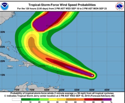
At 500 PM AST (2100 UTC), the center of Tropical Storm Jerry was located near latitude 15.0 North, longitude 50.5 West. Jerry is moving toward the west-northwest near 15 mph (24 km/h). A west-northwest motion at a slightly faster forward speed is expected over the next few days. On the forecast track, the center of Jerry will
be near or north of the northern Leeward Islands Friday and pass north of Puerto Rico on Saturday.
Maximum sustained winds have increased to near 60 mph (95 km/h) with higher gusts. Jerry is forecast to become a hurricane on Thursday, with little change in strength anticipated on Friday or Saturday.
Tropical-storm-force winds extend outward up to 45 miles (75 km) from the center.
The estimated minimum central pressure is 1000 mb (29.53 inches).
HAZARDS AFFECTING LAND
Key messages for Jerry can be found in the Tropical Cyclone
Discussion under AWIPS header MIATCDAT5 and WMO header WTNT45 KNHC.
WIND: Tropical storm conditions are possible within the watch
areas by early Friday.
RAINFALL: Jerry is expected to produce total rainfall accumulations of 1 to 2 inches with maximum amounts of 3 inches across the northern Leeward Islands, the Virgin Islands and Puerto Rico.
SURF: Swells generated by Jerry are forecast to affect portions of northern Leeward Islands late on Thursday. These swells are likely to cause life-threatening surf and rip current conditions.
A STORM WATCH IS NOW IN EFFECT FOR ST. MAARTEN…
JERRY STRENGTHENING OVER THE TROPICAL ATLANTIC…
Location: Lat. 15.0 N ....Lon. 50.5 W About: 850 miles ESE of St. Maarten
Maximum sustained winds: 60 mph ....95 KM/H
Present Movement: WNW...290 degrees at 15 mph…24 KM/H Minimum Central Pressure: 1000 mb....29.53 inches
DISCUSSION AND 24-HOUR OUTLOOK
AT 5:00 PM THE CENTER OF TROPICAL STORM JERRY WAS LOCATED NEAR LATITUDE 15.0 NORTH, LONGITUDE 50.5 WEST OR ABOUT 850 MILES EAST SOUTHEAST OF ST. MAARTEN.
JERRY IS MOVING TOWARD THE WEST-NORTHWEST NEAR 15 MPH (24 KM/H). A WEST-NORTHWEST MOTION AT A SLIGHTLY FASTER FORWARD SPEED IS EXPECTED OVER THE NEXT FEW DAYS.
MAXIMUM SUSTAINED WINDS HAVE INCREASED TO NEAR 60 MPH (95 KM/H) WITH HIGHER GUSTS. JERRY IS FORECAST TO BE A HURRICANE ON THURSDAY, WITH LITTLE CHANGE IN STRENGTH ANTICIPATED ON FRIDAY AND SATURDAY.
TROPICAL STORM FORCE WINDS EXTEND OUTWARD UP TO 45 MILES (75 KM) FROM THE CENTER. THE ESTIMATED MINIMUM CENTRAL PRESSURE IS 1000 MB (29.53 INCHES).
ON THE PRESENT TRACK THE CENTER OF JERRY IS EXPECTED TO PASS APPROXIMATELY 115 MILES TO THE NORTH OF ST. MAARTEN ON FRIDAY NIGHT. EFFECTS OF THIS SYSTEM WILL BEGIN ON ST. MAARTEN BY FRIDAY.
RESIDENTS AND THE GENERAL PUBLIC SHOULD PUT PLANS IN PLACE AND CONTINUE TO BE ALERT AND MONITOR THE PROGRESS OF THIS SYSTEM.
THE METEOROLOGICAL DEPARTMENT OF ST. MAARTEN WILL CONTINUE TO MONITOR THIS SYSTEM AND ISSUE SPECIAL WEATHER BULLETINS.
POTENTIAL IMPACTS:
Rainfall: Jerry is expected to produce total rainfall accumulations of 1 to 2 inches with maximum amounts of 3 inches across the northern Leeward Islands, the Virgin Islands, and Puerto Rico.
Winds: Tropical storm conditions are possible within the watch areas by early Friday.
Seas: Swells generated by Jerry are forecast to affect portions of northern Leeward Islands late on Thursday. These swells are likely to cause life-threatening surf and rip current conditions. Please consult products from your local weather office.