


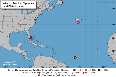
 PHILIPSBURG:--- The National Hurricane Center is issuing advisories on Tropical Depression Chantal, located about 765 miles west of the Azores. 1. Surface and radar data, along with satellite imagery, indicate that the low-pressure area just east of the coast of southeastern Florida is becoming better organized. The low is forecast to move generally northwestward near or over the eastern Florida peninsula through tonight, and then move northward to northeastward over the Atlantic near the east coast of the central Florida peninsula on Saturday. After that, the system is expected to move northeastward offshore of the southeastern United States coast. If the current trend continues, a tropical depression is likely to form by Saturday night. Regardless of development, locally heavy rains are possible over the northwestern Bahamas and the southern and central Florida peninsula through the weekend. Interests in the northwestern Bahamas, the Florida peninsula, and the southeast coast of the
United States should monitor the progress of this system. An Air Force Reserve Hurricane Hunter aircraft is scheduled to investigate the system on Saturday, if necessary.
Recent satellite wind data indicate that a low-pressure area has formed in association with a tropical wave located about 1300 miles east-southeast of the Windward Islands. Additional development of this system is possible during the next few days, and a tropical depression could form late this weekend or early next
week as it moves generally westward to west-northwestward near 15 mph.