


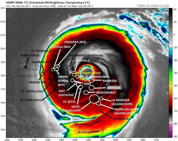
 PHILIPSBURG:--- The government of the Netherlands has issued a Hurricane Watch for the islands of Saba, St. Eustatius, and Sint Maarten/ St. Martin. Other islands such Antigua, Guadeloupe, Barbuda, Anguilla, Montserrat, St. Kitts, and Nevis are all under hurricane watch as of 5 PM Sunday. The information was released by the National Hurricane Center (NOAA). At 5 PM Sunday Hurricane Irma was located at 17.6N 46.8W about 790 miles (1275) KM east of the Leeward Islands. Maximum sustained winds 115 MPH...185 KM/H with movement W or 260 degrees at 14MPH (22KM/H).
SUMMARY OF WATCHES AND WARNINGS IN EFFECT:
A Hurricane Watch is in effect for:-
- Antigua, Barbuda, Anguilla, Montserrat, St. Kitts, and Nevis
- Saba, St. Eustatius, and Sint Maarten
- Saint Martin and Saint Barthelemy
Interests in the remainder of the Leeward Islands, the British and U.S. Virgin Islands, and Puerto Rico should monitor the progress of Irma. Additional Hurricane and Tropical Storm Watches may be
required for portions of this area on Monday. At 500 PM AST (2100 UTC), the center of Hurricane Irma was located near latitude 17.6 North, longitude 49.8 West. Irma is moving toward
the west near 14 mph (22 km/h). A westward to west-southwestward motion with some reduction in forwarding speed is expected through Monday night. On the forecast track, the center of Irma is
forecast to approach the northern Leeward Islands late Tuesday.
Maximum sustained winds are near 115 mph (185 km/h) with higher gusts. Irma is a category 3 hurricane on the Saffir-Simpson Hurricane Wind Scale. Some strengthening is forecast during the
next 48 hours. Hurricane-force winds extend outward up to 35 miles (55 km) from the center and tropical-storm-force winds extend outward up to 140 miles (220 km).
A HURRICANE WATCH IS IN EFFECT FOR ST. MAARTEN...
DATE ISSUED: Sunday, September 3, 2017 TIME ISSUED: 8:15 PM
...IRMA EXPECTED TO BE NEAR THE NORTHERN LEEWARD ISLANDS BY
LATE TUESDAY...
Location: Lat. 17.4N ....Lon. 50.3W
About: 843 miles ESE of St. Maarten
Maximum sustained winds: 115 mph ....185 KM/H
Present Movement: W...260 degrees at 14 mph...22 KM/H
Minimum Central Pressure: 959 mb....28.32 inches
DISCUSSION AND 24-HOUR OUTLOOK
AT 8:00 PM...THE CENTER OF HURRICANE IRMA WAS LOCATED NEAR
LATITUDE 17.4 NORTH...LONGITUDE 50.3 WEST OR ABOUT 843 MILES EAST-SOUTHEAST OF ST.
MAARTEN.
IRMA IS MOVING TOWARD THE WEST NEAR 14 MPH (22 KM/H). A WESTWARD TO WESTSOUTHWESTWARD
MOTION WITH SOME REDUCTION IN FORWARD SPEED IS EXPECTED THROUGH MONDAY NIGHT.
MAXIMUM SUSTAINED WINDS ARE NEAR 115 MPH...185 KM/H...WITH HIGHER GUSTS.
SOME STRENGTHENING IS ANTICIPATED DURING THE NEXT COUPLE OF DAYS.
HURRICANE FORCE WINDS EXTEND OUTWARD UP TO 35 MILES (55KM) FROM THE CENTER AND TROPICAL STORM FORCE WINDS EXTEND UP TO 140 MILES (220KM) FROM THE CENTER.
THE ESTIMATED MINIMUM CENTRAL PRESSURE IS 959 MB...28.32 INCHES.
ON THE FORECAST TRACK, THE CENTER OF IRMA IS FORECAST TO APPROACH THE LEEWARD ISLANDS LATE TUESDAY NIGHT. HOWEVER TROPICAL STORM CONDITIONS IN ST. MAARTEN MAY BE FELT BY LATE TUESDAY.
HAZARDS AFFECTING LAND AND SEA
WIND:
Hurricane conditions are possible in St. Maarten by late Tuesday night however Tropical storm force winds are expected by late Tuesday.
ALL CITIZENS/ RESIDENTS SHOULD REMAIN VIGILANT AND MAKE PREPARATIONS TO PROTECT LIFE AND PROPERTY AND BE READY TO TAKE THE NECESSARY ACTION WHEN CALLED UPON.
THE METEOROLOGICAL DEPARTMENT WILL CONTINUE TO MONITOR HURRICANE IRMA AND ISSUE SPECIAL WEATHER BULLETINS.
The next update will be issued tomorrow at 5:30 am (09:30 UTC).
Monday, September 4th, 2017
At 11:00 AM LST, the center of Hurricane Irma was located near latitude 16.8 North, longitude 53.3 West or about 650 miles east southeast of St. Maarten. Irma is moving toward west southwest at 14 mph (22 km/h) but a turn toward the west is expected later today followed by a west northwestward turn late Tuesday. On the forecast track the center of Irma will move near St. Maarten Tuesday night into Early Wednesday.
Maximum sustained winds are near 120 mph (195 km/h) with higher gusts. Additional strengthening is anticipated through Tuesday night.
The Meteorological Department of St. Maarten (MDS) will continue to monitor the progress of Irma. Members of the public are advised to monitor the updates on this system and make all necessary preparations for its passage.
OUTLOOK through Wednesday midday: Generally cloudy, breezy with scattered showers and isolated thunderstorms.