


 The strongest hurricane to move across the Caribbean Sea in nine years remains a Category 4 storm as of Sunday morning.
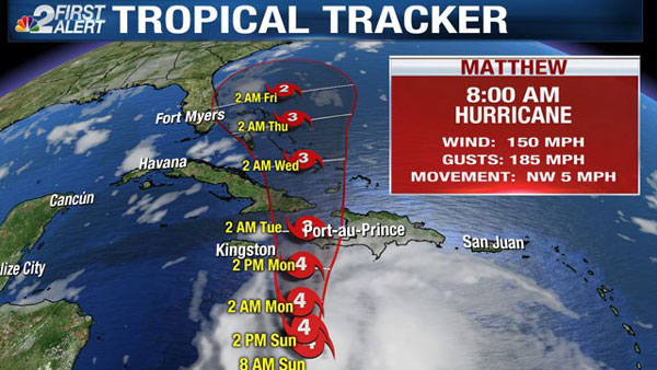
That's according to the latest advisory from the National Hurricane Center. Matthew has an area of maximum sustained winds of 150 mph with gusts to 185 mph.
On Friday, Matthew did reach Cat 5 status becoming the strongest storm to move about the Caribbean since Hurricane Felix in 2007.
- Related: Learn how hurricanes are classified with the Saffir-Simpson Scale
More information on the storm is being collected by Hurricane Hunters as they fly through Matthew on Sunday morning.
Matthew is moving slowly, at only about 5 miles an hour. The anticipated turn has started to take place, with the movement now to northwest. Movement will turn more northerly by late Sunday.
This makes the hurricane a threat to Jamaica, Haiti, Cuba, the Bahamas, and potentially areas of the United States by next week, depending greatly on the eventual track the storm takes. The forecast cone has shifted about 50 miles east of the cone that was out 24-hours ago.
A hurricane warning is active for Jamaica, Haiti and Cuba. Hurricane watches are in place for parts of the Bahamas.
Hurricane Matthew's official forecast cone of concern from the NHC does not currently include any counties in Southwest Florida and only a small part of east Florida by next Friday.
- Related: Track Matthew's movement with our Interactive Hurricane Tracker
It is important to note that though the short-term track of this hurricane is more certain, there is a good deal of uncertainty as to where it will go long term. As of this evening, Matthew is still located nearly 1,000 miles away from the United States. The forecast outlook by Thursday and Friday still includes uncertainty.
Matthew's forecast cone suggests the center of the storm could be as far west as just off the coast of Miami by Thursday or as far east as over the Atlantic Ocean east of the Bahamas. Since there is such a high degree of uncertainty so many days out, all of the southern portion of Florida should continue to monitor developments with the storm closely the next several days.
In regards to Southwest Florida, our weather toward the end of next week will hinge entirely on the path Matthew eventually takes. If it takes a path more westerly, greater amounts of rain and wind can be expected in areas of Florida. However, if the hurricane favors a more eastern route, the state could be greatly untouched, especially on the west coast.
The latest forecast cone, analysis and data from the NHC are available on our NBC2 Newscasts starting Sunday morning at 6 a.m.
St Maarten Weather Report:
Today through Monday morning: Partly cloudy, becoming cloudy at times with isolated showers.
Forecast High: 31°C / 88°F Forecast Low: 27°C / 81°F
Sunset Today: 6:00 P.M. Sunrise Tomorrow: 6:03 A.M.
SURFACE WINDS:
Today through Monday morning: Southeasterly with gentle to moderate breeze of 08 to 15 miles per hour.
SYNOPSIS:
A tropical wave approaching the region will account for an increase in moisture and instability across the local area. As a result, occasional cloudiness and isolated showers are expected during this forecast period.
Furthermore, seas are will be slight to moderate for the next several days, peaking near 5 feet.
STATE OF THE SEA: Slight to Moderate WAVES/SWELLS: 3 to 5 feet
SPECIAL FEATURE:
As of 5am, Matthew remains a dangerous category 4 hurricane with maximum sustained winds of 150 mph. Matthew poses no threat to St. Maarten.
OUTLOOK through Tuesday morning: Partly cloudy to cloudy with isolated showers.