


 Tonight through Thursday evening: Cloudy to overcast and windy with scattered showers, some of which could be heavy, and possible thunderstorms.
Forecast High: 28°C / 82°F Forecast Low: 24°C / 75°F
Sunset Today: 6:03 P.M. Sunrise Tomorrow: 6:03 A.M.
SURFACE WINDS:
Tonight through Thursday evening: Northeast to east with moderate to strong breeze of 15 to 30 miles per hour, with higher gusts.
SYNOPSIS:
Deteriorated weather conditions are expected as the center of Tropical Storm Matthew passes south of the region. Outer bands of the storm will continue to cause cloudiness, gusty winds, and scattered showers over the local region. Some of these showers may be heavy and can be accompanied by thunderstorms. Residents and motorists in areas prone to flooding should take precautions as street-flooding is likely.
Hazardous seas are expected throughout the forecast period. Consequently a small craft warning is in effect for St. Maarten. Small craft operators and coastal residents are advised to take steps to protect life and property.
This afternoon: September 28th 2016: Generally cloudy, hazy and windy with isolated showers possible.
Tonight through Thursday midday: Cloudy and windy, becoming overcast at times with scatter showers, some of which could be heavy, with possible isolated thunderstorms.
Forecast High: 30°C / 86°F Forecast Low: 27°C / 81°F
Sunset Today: 6:03 P.M. Sunrise Tomorrow: 6:03 A.M.
SURFACE WINDS:
This afternoon through Thursday midday: East northeast to east with moderate to strong breeze of 14 to 30 miles per hour, with higher gust.
SYNOPSIS:
A deterioration in weather condition is expected as Tropical Storm Matthew passes south of the region. Spiral bands from this system will cause a surge in moisture and instability across the local area. As a result increased cloudiness, scattered showers some of which could be heavy and possible isolated thunderstorms with gusty winds can be expected.
Residents in flood prone areas and motorist should take precautions as heavy showers may cause flooding.
Hazardous seas are expected during the next 48 hours with waves peaking near 10 to 14 feet .Consequently a small craft warning is in effect for St. Maarten. Small craft operators and property owners near the coast are advised to take steps to protect life and property.
STATE OF THE SEA: Rough to very rough WAVES/SWELLS: 10 to 14 feet
SPECIAL FEATURE:
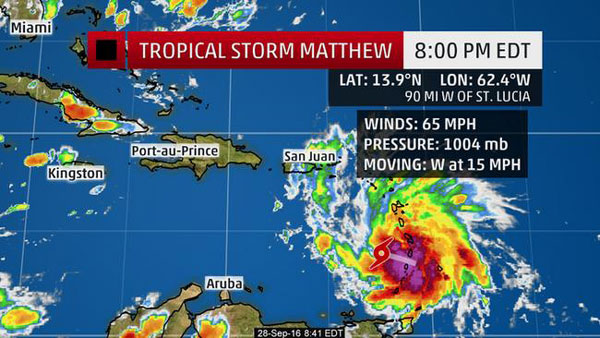
At 11 am the strong tropical wave located just east of the region was upgraded to Tropical Storm Matthew. This system is about 314 miles south southeast of St. Maarten and is moving toward the west near 21 mph with maximum sustained winds of 60 mph. On this forecast track, the center of Matthew will move through the Windward Islands during the next few hours and into this evening.
An increase in wind speed, cloudiness, showers and possible thunderstorm activity along with a strong winds and hazardous sea conditions are expected across the local area.
The Meteorological Department of St. Maarten will continue to monitor this system.
OUTLOOK through Friday midday: At first, generally cloudy and windy with scattered showers, some of which could be heavy with isolated thunderstorms. (Flooding in low lying areas may be possible). Then a gradual improvement from later Thursday into Friday.