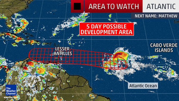
 The National Hurricane Center has given this system a high chance for formation into a tropical depression over the next 2 to 5 day period as it nears the Lesser Antilles into the Caribbean. The next named storm in the Atlantic would be Matthew.
It should be noted this disturbance is starting out at a fairly low latitude, south of 10 degrees. Therefore, showers and gusty winds are expected in such locations as St. Vincent and the Grenadines, Grenada, Trinidad and Tobago, perhaps even coastal Venezuela later this week.
(MORE: Hurricane Central)
Caribbean Questions
By Thursday, the system, either still a tropical wave, depression, or Tropical Storm Matthew, will move into the eastern Caribbean Sea.
Again, given the potential far southern track, there could be rain and gusty winds in the typically drier "ABC Islands" - Aruba, Bonaire and Curaçao - Thursday.
Beyond that, uncertainty is high on this system's future.
There are currently west to northwest winds aloft over the Caribbean Sea, providing some wind shear which is typically hostile to the development and intensification of tropical cyclones.
The National Hurricane Center has given this system a high chance for formation into a tropical depression over the next 2 to 5 day period as it nears the Lesser Antilles into the Caribbean. The next named storm in the Atlantic would be Matthew.
It should be noted this disturbance is starting out at a fairly low latitude, south of 10 degrees. Therefore, showers and gusty winds are expected in such locations as St. Vincent and the Grenadines, Grenada, Trinidad and Tobago, perhaps even coastal Venezuela later this week.
By Thursday, the system, either still a tropical wave, depression, or Tropical Storm Matthew, will move into the eastern Caribbean Sea.
Again, given the potential far southern track, there could be rain and gusty winds in the typically drier "ABC Islands" - Aruba, Bonaire and Curaçao - Thursday.
Beyond that, uncertainty is high on this system's future.
There are currently west to northwest winds aloft over the Caribbean Sea, providing some wind shear which is typically hostile to the development and intensification of tropical cyclones.