~France Regains Authority in Oyster Pond, but the Full Cost to St. Maarten Cannot Be Measured Without the Cadastral Maps~
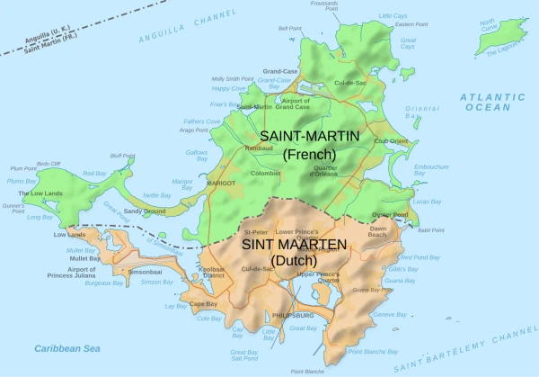 PHILIPSBURG/MARIGOT:--- Who won when France and the Kingdom of the Netherlands finally agreed on the international boundary between Saint-Martin and St. Maarten?
The most defensible answer is that France achieved its main legal objective in Oyster Pond, while St. Maarten gained certainty, continued navigation rights and protection for existing interests—but gave up the historic Dutch claim that the entire pond fell under its jurisdiction.
That conclusion emerges not only from the treaty’s maps and coordinates, but from the unusually direct language used in the French Senate’s official report.
For decades, Dutch authorities exercised powers over areas in and around Oyster Pond that France believed were French territory. Dutch permits were issued, leases were granted, taxes were collected and businesses operated under St. Maarten law.
The French parliamentary record now describes that situation as an erosion of French sovereignty.
It states that the final boundary follows the position defended by France and that the agreement restores France’s ability to apply its laws in territory where Dutch authority had previously been exercised in practice.
This does not mean France acquired territory that was unquestionably Dutch.
It means the two countries settled an unresolved sovereignty dispute by rejecting the old Dutch position that Oyster Pond belonged entirely to St. Maarten and adopting a divided boundary based on equidistance.
For St. Maarten, that is the central territorial concession contained in the agreement.
But the official documents do not yet provide enough public cadastral information to calculate how many square meters changed jurisdiction, which individual parcels are affected, or the financial value of the land and water involved.
The treaty tells the public exactly where the new international line runs.
It does not provide a public parcel-by-parcel balance sheet showing who gained and who lost each property.
The treaty map shows one continuous frontier
Annex C of the treaty provides the broad visual answer.
The boundary begins at Point D, east of Oyster Pond, passes through the pond and then crosses the island toward the west before connecting with Point C near the western coast.
The indicative map shows Saint-Martin north of the line and St. Maarten south of it. It also shows the land frontier connecting directly to the maritime boundary established by the two countries in 2016.
The eastern section is the most politically significant because the line does not simply follow the French shoreline around Oyster Pond.
Instead, it enters and divides the pond.
That visual distinction represents the collapse of the former Dutch claim to all the waters of Oyster Pond. The treaty fixes the pond section through 15 numerical points, followed by 392 coordinate points across the land boundary.
The map in Annex C is only illustrative. Article 16 makes clear that the legally controlling boundary is found in Annex A’s coordinates, not in the thickness of the line printed on the general map.
A property owner therefore cannot determine legal jurisdiction merely by enlarging the treaty map.
The coordinates must be professionally plotted against cadastral plans, surveyed structures, registered parcels, roads and shoreline features.
Oyster Pond was the real battle
The dispute was never equally intense across the entire land border.
For most of the island, an accepted customary frontier had gradually developed through ridgelines, roads, walls, monuments and other physical features.
Oyster Pond was different.
The French Senate report states that a 1955 map produced from French IGN surveys incorrectly placed the border along the French shoreline, effectively attributing the whole pond to the Dutch side.
That map influenced administrative practice for decades and weakened the French position.
The result was an unusual conflict between legal claim and practical control.
France maintained that the pond should be divided.
St. Maarten authorities acted as though the waters were Dutch.
The Senate report says an informal median line eventually developed as a practical arrangement, but it lacked a firm legal basis. Meanwhile, Dutch permits and long-term leases allowed economic activity to proceed under St. Maarten’s system.
The dispute therefore went far beyond cartography.
It determined:
- which country could issue building and marina permits;
- which tax system applied;
- which labour and social-security laws govern businesses;
- which police force could intervene;
- which prosecutor had jurisdiction;
- which government could regulate fuel storage and environmental risks;
- and which country was responsible for reconstruction after a hurricane.
The old Dutch claim: the entire pond
The official French record describes the competing positions clearly.
France argued for a division based on equidistance.
The Netherlands maintained a claim to exclusive sovereignty based substantially on longstanding administrative practice and the effective exercise of authority.
According to the Senate report, the Dutch position became increasingly difficult to sustain under international legal principles because it would have placed waters adjoining the French shoreline entirely under Dutch sovereignty.
In 2021, the Dutch side accepted the principle of dividing Oyster Pond according to equidistance.
That change removed the principal obstacle blocking the negotiations and opened the way for the agreement signed in 2023.
The decisive territorial outcome is therefore clear:
St. Maarten did not retain the whole of Oyster Pond.
The pond is now legally divided.
France describes the outcome as a restoration of sovereignty
The French Senate did not present the treaty as a neutral technical exercise.
Its report is explicitly titled around ending historical ambiguity and preserving French sovereignty.
The report says the agreement:
- restores effective French sovereignty;
- clarifies which law applies;
- allows French authorities to act in previously disputed areas;
- strengthens policing and public administration;
- and secures economic activity and investment.
It also states that the chosen delimitation corresponds to the position defended by France.
That is the clearest official answer to the question of who prevailed in the main dispute.
France believes it did.
The French parliamentary interpretation is that St. Maarten had exercised authority in waters that were not lawfully all Dutch and that the new agreement corrects that situation.
That is France’s official position. It should not automatically be presented as a complete, independent assessment of every negotiated concession, because the French report is written to justify ratification to French lawmakers.
However, the treaty itself confirms the central factual outcome: Oyster Pond is divided rather than allocated completely to St. Maarten.
Captain Oliver’s became the symbol of the dispute
No location illustrates the practical consequences more clearly than the former Captain Oliver’s marina and hotel-restaurant complex.
According to the French Senate report, a French sub-prefect declared in 1983 that he lacked jurisdiction to authorize construction at the site, relying on the map that treated the pond as Dutch.
Construction then proceeded under permits issued by St. Maarten authorities.
In 1989, Dutch authorities reportedly granted 60-year maritime leases to NV Cactus Tree, allowing the operation to function under Dutch law, taxation and labor arrangements.
French tax authorities later granted property tax relief on the grounds that the site was situated in St. Maarten waters.
In 2015, the Court of Appeal in Basse-Terre also treated the operation as a Dutch-law company situated in Dutch waters for the case before it.
These decisions created what the French report calls an administrative and legal reality in which Dutch authority was exercised over contested waters even though France had not formally abandoned its sovereign claim.
The result was years of contradictory enforcement.
French and St. Maarten authorities disagreed over inspections, searches, pollution incidents, fuel storage and control of vessels.
At times, officials or private operators challenged French authority by asserting that the marina was situated entirely in St. Maarten.
The Senate report records incidents involving police searches, maritime enforcement, narcotics investigations and environmental intervention that were obstructed or disputed because no one could point to a ratified boundary.
Irma destroyed the status quo
The dispute might have continued much longer had Hurricane Irma not devastated the island on September 6, 2017.
Captain Oliver’s marina and surrounding infrastructure were heavily damaged.
Reconstruction required new permits, financing, environmental review, and certainty about which government possessed legal authority.
The old arrangement—where the parties tolerated practical ambiguity—was no longer workable.
The French Senate says Irma exposed the urgency of resolving the issue because neither reconstruction nor economic redevelopment could proceed safely while jurisdiction remained disputed.
The hurricane did not create the border dispute.
It destroyed the physical and economic structures that had allowed both sides to postpone solving it.
What France gained
France’s principal gain is not simply an area of water.
It is the restoration of uncontested governmental authority within the French portion of Oyster Pond.
Once the treaty enters into force, France will have a stronger legal basis to:
- apply French planning and construction rules;
- enforce French labour and social laws;
- impose French taxation where applicable;
- conduct policing and criminal investigations;
- regulate environmental risks;
- supervise business activity;
- update cadastral records;
- and control reconstruction in the French section.
The Senate report expressly says that economic activities in the affected areas can be placed unambiguously under French fiscal, social and labour law.
France also gains formal recognition that the pond is not wholly Dutch.
That is the core sovereign victory.
What St. Maarten gained
St. Maarten did not leave the negotiations empty-handed.
The agreement provides something that years of administrative practice could not: internationally recognized legal certainty.
The Kingdom secured:
- an agreed Dutch section of Oyster Pond;
- a continuous frontier connected to the 2016 maritime boundary;
- guaranteed access and navigation for Dutch-flagged vessels;
- anchoring and traditional fishing rights;
- protection of acquired rights;
- mechanisms for resolving affected property and business situations;
- and equal participation in the Mixed Commission overseeing the frontier.
The treaty declares Oyster Pond internal waters but guarantees innocent passage for vessels of every nationality. It also provides reciprocal access, navigation, anchoring and traditional fishing for French and Dutch vessels in Oyster Pond and Simpson Bay Lagoon, subject to the applicable laws.
These protections are significant.
They ensure that legal division does not mean commercial isolation or physical exclusion.
St. Maarten also gains certainty for future permitting, enforcement and investment. Businesses will no longer be able to exploit uncertainty by selecting whichever legal system appears more favourable.
Government will know where its authority ends.
That may be less dramatic than a territorial victory, but it is valuable.
Was Dutch administrative control converted into French territory?
That depends on how the word “territory” is used.
The agreement does not transfer territory in the conventional sense of one country formally ceding an undisputed possession to another.
Instead, it resolves a disputed boundary.
France always maintained that part of Oyster Pond was French.
St. Maarten acted for decades as though the entire pond was Dutch.
The treaty settles the disagreement by dividing the waters.
From the perspective of practical administration, France gains control over areas where St. Maarten had previously exercised authority.
From the perspective of France’s legal claim, France is not gaining new territory; it is securing recognition of territory that it always believed belonged to it.
From the perspective of the former Dutch claim, St. Maarten relinquishes exclusive control.
Both descriptions can be true because legal sovereignty and effective administrative control had diverged.
What happens to the Dutch leases?
This may become the agreement’s most difficult legal test.
The Senate report highlights the 1989 maritime leases associated with Captain Oliver’s and questions how they will operate under French law if their location now falls in the French section.
The lease term was reportedly 60 years, which would extend to 2049.
The treaty protects acquired rights, but it also states that affected activities continue under the laws applicable in the territory where they are situated.
That creates a potential collision between:
- rights originally granted by Dutch authorities;
- the treaty’s promise to protect acquired rights;
- and France’s sovereign authority to apply French law.
The French Senate warns that the transition could generate litigation if it is not carefully managed.
The treaty does not simply cancel every previous Dutch permit or lease.
Nor does it guarantee that every Dutch authorization can continue unchanged.
Instead, Articles 11 and 12 require the parties to preserve acquired rights while resolving registrations and administrative situations after entry into force.
That balancing exercise may prove far more contentious than the signing ceremony.
The cadastral question remains unanswered
The treaty contains 392 land points, but it does not list the owners of affected parcels.
It requires property and other registrable interests to be entered into the correct mortgage, cadastral or other official registers within two years after the agreement enters into force.
Where necessary, property is to be entered in one jurisdiction’s register and removed from the other’s.
That provision confirms that the boundary may affect existing records.
But neither the treaty nor the general map answers publicly:
- how many parcels are involved;
- which owners will be contacted;
- whether buildings cross the line;
- whether any businesses will switch jurisdiction;
- whether mortgages or leases must be re-registered;
- whether permit holders must apply again;
- or whether financial compensation will be paid.
Until the 392 coordinates are overlaid on both sides’ cadastral databases, no government can credibly provide a complete answer about territorial gains and losses on land.
Why the map cannot settle property disputes
Annex C shows the border on a small-scale island map.
It is suitable for understanding the overall direction of the frontier.
It is not suitable for determining whether a wall, home, business, marina installation or driveway is French or Dutch.
At that scale, the printed line itself may cover a large strip of ground.
The binding legal instrument is Annex A, which lists the latitude and longitude of each point.
Successive points are connected by straight geodetic lines.
A proper property determination will therefore require:
- transforming the treaty coordinates into the surveying system used for the relevant cadastral records;
- plotting the geodetic segments;
- locating the surveyed parcel boundaries and structures;
- checking titles, leases, mortgages and permits;
- and determining whether the existing legal registration corresponds with the treaty.
That work cannot be replaced by political statements or rough visual estimates.
The 1915 Werbata map is evidence—not the final word
Annex D incorporates the historic Werbata map produced from early 20th-century topographical surveys.
The map is important because it reflects the historically accepted land frontier before later cartographic errors complicated the Oyster Pond dispute.
But the Werbata map is not itself the final legal border.
Article 3 allows the Mixed Commission to take it into account when proposing future technical adjustments to Annex A.
For Oyster Pond, the Commission must instead consider equidistance.
The treaty therefore creates a hierarchy:
- the numerical coordinates control;
- the modern map illustrates them;
- the Werbata map assists with historical interpretation;
- and the Mixed Commission can propose corrections, subject to approval by both governments.
The line may still be technically adjusted
The border is described as definitive, but the coordinates are not entirely untouchable.
The Mixed Commission may propose adjustments where technical inconsistencies emerge.
Annexes A and B may be amended through an exchange of diplomatic notes between the parties.
This does not allow St. Maarten or France to alter the boundary unilaterally.
Any change requires agreement.
The procedure appears designed to correct surveying or coordinate issues rather than reopen the political settlement.
Still, property owners should understand that field implementation may expose discrepancies requiring technical correction.
Higher Bethlehem, Belle Plaine and claims not proved by the treaty alone
Public descriptions surrounding the 2023 signing have suggested that the overall settlement included adjustments in areas such as Belle Plaine, Oyster Pond Road and Higher Bethlehem.
However, the official treaty does not explain the boundary as a political trade-off in which one named district was “given” to one side in exchange for another.
It supplies coordinates.
To verify claims about Higher Bethlehem or any other named area, the new coordinate line must be compared against:
- the previously administered boundary;
- the Werbata line;
- official cadastral maps;
- and the negotiating maps showing the positions originally claimed by both sides.
Without that comparison, it would be irresponsible to state as an established fact that a named parcel or neighbourhood was transferred.
The French report proves that France prevailed on the Oyster Pond principle.
It does not provide a complete public ledger calculating all compensating adjustments elsewhere.
Who will pay for implementation?
The treaty says France and the Kingdom will each pay half the costs of border demarcation and maintenance.
If new border work is required because of a concession project, the concession holder bears the relevant cost.
The Mixed Commission may also require a strip up to four metres wide—two metres on each side—to be kept free of vegetation where needed for access, observation and maintenance.
This raises immediate questions for St. Maarten:
- Which ministry has budgeted for the work?
- How much will surveying and physical marking cost?
- Will private owners be expected to maintain walls used as border markers?
- Who pays when a property owner disputes the location?
- What happens where clearing affects landscaping or commercial use?
- Will compensation be provided for required access?
The treaty establishes obligations but does not supply a local implementation budget.
No clear compensation clause
The agreement protects acquired rights but contains no broad, automatic compensation scheme for persons who suffer financial loss because their property, permit or business becomes subject to another jurisdiction.
That does not necessarily mean compensation can never be claimed.
Rights may arise under domestic law, property law, administrative law or other legal protections.
But the treaty itself does not promise payment simply because someone faces new registration, taxation, permit or regulatory obligations.
That omission could become controversial if businesses are forced to make costly changes.
One island, two legal systems—and now a precise line
The agreement does not erase the profound differences between both sides.
The French territory operates under French and European Union law.
St. Maarten operates as an autonomous country within the Kingdom of the Netherlands with its own laws, taxation and regulatory system.
The French Senate itself identifies differences in taxation, social protection, economic regulation and entry requirements as factors influencing cross-border behaviour.
The new line therefore has consequences far beyond sovereignty.
A movement of only a few metres can determine:
- which tax authority collects revenue;
- which labour code applies;
- which court hears a dispute;
- which environmental standard governs;
- which building code controls;
- which police force investigates;
- and which government may issue a permit.
This is why the unanswered cadastral questions matter.
So, who won?
On the narrow question that blocked negotiations for decades, France won the legal argument.
The Dutch claim to exclusive sovereignty over Oyster Pond was not accepted.
The pond was divided according to equidistance, the solution France had long advocated.
France obtained formal recognition of jurisdiction in waters where St. Maarten had exercised practical authority.
The French Senate openly celebrates that outcome as the restoration of French sovereignty.
St. Maarten, however, secured an internationally recognized section of Oyster Pond, guaranteed navigation and traditional-use rights, protection for acquired interests and a stable border that will support future permitting, enforcement and investment.
The settlement is therefore not a total defeat for St. Maarten.
But it is a retreat from the historical Dutch position.
The final answer is still hidden in government maps
The public cannot yet calculate the full territorial outcome.
To do that, the Government of St. Maarten should release:
- a high-resolution cadastral overlay of all 392 land points;
- a detailed Oyster Pond map identifying structures, leases and marine installations;
- the former Dutch claimed line;
- the French claimed line;
- the agreed line;
- a list of affected parcels and registered interests;
- and an implementation plan explaining taxation, licences, permits and property registration.
Until those documents are public, claims that St. Maarten either “lost nothing” or “gave away territory” remain incomplete.
What can be stated with confidence is that the treaty replaces Dutch control over the whole of Oyster Pond with a legally divided pond.
France considers that a restoration of sovereignty.
St. Maarten must now explain to its people what was accepted in return, which properties and businesses are affected and whether the legal protection of existing rights will be sufficient.
After 377 years, the international line has finally been agreed.
The next battle may not be between France and the Kingdom of the Netherlands.
It may be between the new coordinates and the old permits, titles, leases and expectations built around a border that was never properly defined.