 Tropical Storm Matthew is now entering the eastern Caribbean Sea and is forecast to strengthen into a hurricane, posing a threat to parts of the Caribbean basin and possibly parts of the U.S. later next week. Matthew was the 13th named storm of the 2016 Atlantic hurricane seas
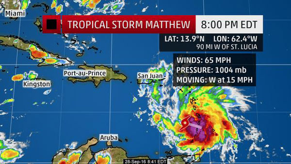
Tropical Storm Matthew is now entering the eastern Caribbean Sea and is forecast to strengthen into a hurricane, posing a threat to parts of the Caribbean basin and possibly parts of the U.S. later next week. Matthew was the 13th named storm of the 2016 Atlantic hurricane season on.
Rainfall accumulations of 4 to 8 inches are expected across the Windward Islands and the southern Leeward Islands through Thursday. Life-threatening flash flooding is possible.
Rainfall of 1 to 2 inches can be expected farther north across the northern Leeward Islands plus the Virgin Islands and Puerto Rico.
Accumulations will range from 1 to 3 inches across the Leeward Antilles including Aruba, Bonaire, and Curaçao through Friday.
Caribbean Questions
Given the southern track, there could be some outer bands of rain and gusty winds in the typically drier "ABC Islands" – Aruba, Bonaire and Curaçao – as well as parts of coastal Venezuela and Colombia Thursday through early Saturday.
Beyond that, uncertainty is still considerable on the critical details of this system.
Over the next couple of days, Matthew should continue to move toward the west or just a smidge north of west as it ridges the southern periphery of the Bermuda High westward.
In general, ensemble forecast guidance suggests Matthew should make a northwest or even northward turn in the Caribbean Sea sometime this weekend, as the system reaches the southwestern edge of the Bermuda high.